February 25, 2006 We just left Richards Bay, South Africa
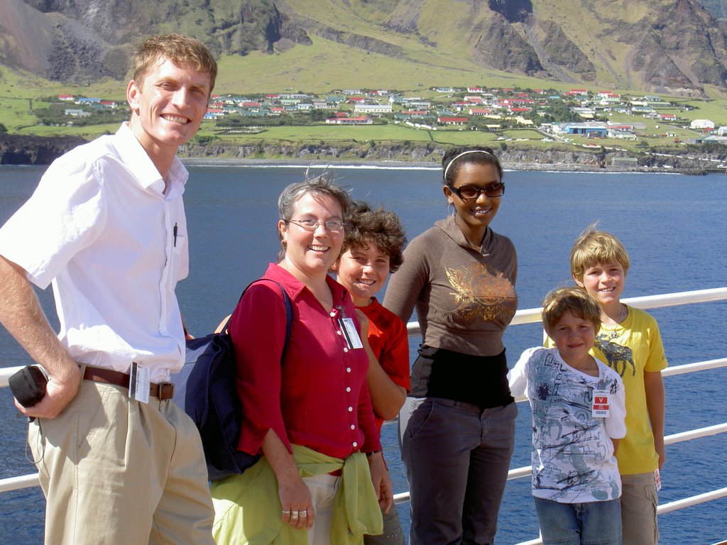
As you can tell, it is difficult to get Alemitu to write. Yesterday she had the excuse that she was invited by a passenger to go to Zululand. It was quite an experience and she managed to take about 200 photos, exhausting the battery on Carter’s camera.
Carter and I stayed on board, trying to avoid the intense heat and humidity. I spend quite a bit of time watching the 3 containers shipped from Seattle be unloaded. Actually, I wished I could have stood IN the containers while they were unloading because 2 of them were freezer units. There were 3 fork lifts working and a ton of workers on the dock – along with supervisors shouting out orders. The ship’s personnel were going crazy to get the frozen stuff in pronto, but the workers were less stressed. I’m sure they work in this heat daily and see little need to work any faster. We also watched the removal of the black water (sewage), which seems to be pretty standardized around the world. It is amazing all the work that goes on behind the scenes on the ship.
We continue to face the battle of the bulge. Even their vegetables are drenched in some sort of good tasting oil. The only “untainted” veggies are the raw ones. Several salads daily are on my menu. We do get delicious fresh fruits in some of the ports, many times they are shipped air freight from Australia. Love those raspberries and blueberries in Feb.
Winnie
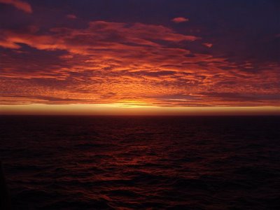
I am amazed at the beauty of the sunrises and sunsets at sea. This is a simpler life indeed and I am going to share a note from Ken Markel who has done 3 world cruises;
"Carter,
I just went thru your flickr photos (I told you my nephew invented flickr?).
They were so wonderful! It took me back to a different time, when I was
much younger and going through the adventure of a lifetime. It was so
exciting and new and wonderful. It would be difficult for anyone who has not
done such a trip to fully wonder at your photos and your adventure....the
isolatiion, sights, Capt Cook type of spirit, the life on ship - elegance of
food and dress etc etc. Tell Mr Ebbens that he looks exactly the same as he
did 15 years ago - at least from that 1 picture he hasn't aged a minute. I'm
so happy you took yourself out of those horrible nighshifts to this fairy
tale adventure.
Ken"
Carter
Februry 28, 2006
Welcome to Nosy Be, Madagascar
Nosy Be is an island just off the northwest coast of Madagascar. Nosy Be means “big island” in the Malagasy language. The island was called Assada during the early colonial era of the 17th century. Nosy Be is Madagascar's largest and busiest tourist resort. The volcanic island has an area of about 120 square miles (300 square kilometers) and reaches a peak on Mont Passot at 1079 feet (329 meters). It is located about 5 miles (8 kilometers) off the coast off the coast of Madagascar. Madagascar has a very diverse geography. The east coast of Madagascar has lowlands leading to steep bluffs and central highlands. The Tsaratanana Massif in the north has volcanic mountains. The west coast has many protected harbors and broad plains, while the southwest is a plateau and desert region. There are two seasons: it is hot and rainy from November to April, and cooler and dry from May to October. Southeastern trade winds dominate, and there are occasional cyclones. Madagascar's long isolation from the neighboring continents has resulted in a unique mix of plants and animals, many found nowhere else in the world; some ecologists refer to Madagascar as the “eighth continent”. The eastern, or windward, side of the island is home to tropical rainforests, while the south eastern and southern sides of the island, which lie in the rain shadow of the central highlands, are home to tropical dry forests, thorn forests, and deserts and xeric shrub lands.
madagascar demographics
Madagascar’s population is predominantly of mixed Asian and African origin. Recent research suggests that the island was uninhabited until Indonesian seafarers arrived between about 2,000 to 1,500 years ago. Recent DNA research shows that the Malagasy are approximately of half Indonesian and half East African stock, although some Arab influence is present as well.
madagascar foreign affairs
Madagascar, which has historically been perceived as on the margin of mainstream African affairs, eagerly rejoined the African Union in July 2003 after a 14-month hiatus triggered by the 2002 political crisis. From 1978 until 1991, then-President Ratsiraka emphasized independence and nonalignment and followed an "all points" policy stressing ties with socialist and radical regimes, including North Korea, Cuba, Libya, and Iran. Taking office in 1993, President Albert Zafy expressed his desire for diplomatic relations with all countries. Early in his tenure, he established formal ties with South Korea and sent emissaries to Morocco. Starting in 1997, globalization encouraged the government and President Ratsiraka to adhere to market-oriented policies and to engage world markets. External relations reflect this trend, although Madagascar's physical isolation and strong traditional insular orientation have limited its activity in regional economic organizations and relations with its East African neighbors. It enjoys closer and generally good relations with its Indian Ocean neighbors: Mauritius, Reunion, and Comoros. Active relationships with Europe, especially France, Germany, and Switzerland, as well as with Britain, Russia, Japan, India, and China have been strong since independence. More recently, President Ravalomanana has cultivated strong links with the United States, and Madagascar was the first country to benefit from the Millennium Challenge Account (MCA). President Ravalomanana has stated that he welcomes relations with all countries interested in helping Madagascar to develop. He has consciously sought to strengthen relations with Anglophone countries as a means of balancing traditionally strong French influence.
February 27, 2006
Madagascar’s History
The written history of Madagascar began in the 7th century, when Arabs established trading posts along the northwest coast. European contact began in the 1500s, when Portuguese sea captain Diego Dias sighted the island after his ship became separated from a fleet going to India. In the late 17th century, the French established trading posts along the east coast. It was a favorite haunt for pirates, including Americans, one of whom brought Malagasy rice to South Carolina. Beginning in the 1790s, Merina rulers succeeded in establishing hegemony over the major part of the island. In 1817, the Merina ruler and the British governor of Mauritius concluded a treaty abolishing the slave trade. British influence remained strong for several decades. The British accepted the imposition of a French protectorate over Madagascar in 1885 in return for eventual control over Zanzibar (now part of Tanzania). Absolute French control was established by military force in 1895, and the Merina monarchy was abolished. Malagasy troops fought in France, Morocco, and Syria during World War II. After France fell to the Germans, the Vichy government administered Madagascar. British troops occupied the strategic island in 1942 to preclude its seizure by the Japanese. The free French received the island from the United Kingdom in 1943. In 1947, a nationalist uprising was suppressed after several months of bitter fighting. The French subsequently established reformed institutions in 1956 and Madagascar moved peacefully toward independence. The Malagasy Republic was proclaimed on October 14, 1958, as an autonomous state within the French Community. A period of provisional government ended with the adoption of a constitution in 1959 and full independence on June 26, 1960.
February 26, 2006
Dining Room Manager Steven Casteels
Steven was born and raised in Belgium in the beautiful city of Ghent, located in between Bruges and Brussels. He followed a hotel education and as he says watched too much love boat on Television. After working in several renowned restaurants and hotels he boarded the Royal Viking Sun as a waiter in 1993. Later on the ship was named the Seabourn Sun and when it became the Prinsendam in 2002, he moved to Holland America Line and has been working on several of his ships. He was the first Pinnacle manager of the fleet on the ms Ryndam, he worked as a Maitre D’ on all Vista Class ships, the ms Rotterdam and on January 4, 2006 he came back to his first love, the ms Prinsendam, to start his 9th World Cruise. He just loves traveling the world, getting a glance of all the different cultures and places. While at home he lives like a true Belgian: He likes to take out his adorable girlfriend for dinner to the many fantastic restaurants Belgium possesses, or he prepares a home cooked meal while using fresh ingredients all the time. On cold winter nights (and others) he relaxes by the fireplace with an exquisite glass of wine. A nice cheese selection or some mouthwatering Belgian Chocolates are never far away... His motto is: you only live once, it's more fun and easier to enjoy it with a smile!
Madagascar’s Economy
The economy of Madagascar is overwhelmingly agricultural, largely of a subsistence type; the best farmland is in the east and northwest. The principal cash crops are coffee, vanilla, sugarcane, cloves, and cocoa. The main food crops are rice, cassava, bananas, beans, and peanuts. In addition, large numbers of poultry, cattle, goats, sheep, and hogs are raised. Fishing and forestry are also important. Manufactures are mostly confined to agricultural products, beverages, and textiles. There is also some oil refining and automobile assembly. The chief minerals extracted are chromite, graphite, coal, bauxite, salt, zircon, industrial beryl and garnets, and offshore oil. There is an extensive but degraded road system (now being repaired) and only a limited rail network. Toamasina and Mahajanga are the chief ports. Madagascar carries on a relatively small foreign trade, and the annual value of imports is usually higher than the value of exports. The main imports are metals, machinery, petroleum, transport equipment, consumer goods, and food products. The leading exports are coffee, vanilla, shellfish, sugar, textiles, chromite, and petroleum products. The principal trade partners are France, Japan, Italy, and the United States. Madagascar relies heavily upon assistance from members of the European Union and international agencies.
February 25, 2006
Culinary Explorations Guest Chef Mat Wolf
Mat Wolf is among the new breed of New Orleans cooks. Born and schooled in the Northwest, Wolf arrived in the city in 1992 at the age of 19, armed with a brand-new associate’s degree in culinary arts from South Seattle Community College and the determination to broaden his culinary vision in a town filled with legendary restaurants. He first took a job as a line cook at Commander’s Palace under the late Chef Jamie Shannon and spent two years there, gaining a firsthand education in the techniques and ingredients used to create the deep, classic flavors so long identified with the New Orleans style. Then came three years at Gautreau’s, first as a line cook and eventually as sous-chef. Gautreau’s at the time was a young restaurant in the forefront of the local movement to bring a more contemporary finesse to the city’s restaurant menus. In 1998, Wolf returned to Seattle, first to join Chef James Drohman’s kitchen staff at Champagne, widely recognized as the city’s premier interpreter of French Provençale cuisine, and two years later to cook under Chef Christine Keff at Flying Fish, where, as Keff’s sous-chef, Wolf was able to indulge his passion for creating seafood dishes. In June 2002, he returned to New Orleans to become executive chef at Gautreau’s, ready to use the restaurant’s longstanding and distinctive menu style as the template for his own dishes, which balance richness with restraint and deliver full yet clean flavors.
Mongolian Cookout
Executive Chef Ed and his culinary team have prepared a unique and delicious Mongolian-style cookout on Lido Deck 11, poolside from 11:30 am to 2:00 pm. Chose your favorite items from a wide selection of meats, seafood, vegetables and starches Use any combination of sauces and spices to create your own flavor profile! One of our talented chefs will cook up your own creation before your eyes for your immediate enjoyment!
Explorer David Livingstone
David Livingstone, 1813 – 1873, was a Scottish missionary and explorer in Africa and the first European to cross the African continent. From 1841 to 1852, while a medical missionary for the London Missionary Society in what is now Botswana, he crossed the Kalahari desert and reached Lake Ngami in 1849. He discovered the Zambezi River in 1851. Hoping to abolish the slave trade by opening Africa to Christian commerce and missionary stations, he traveled to Luanda on the west coast in 1853. Following the Zambezi River, he discovered and named Victoria Falls in 1855. Appointed British consul at Quelimane, he was given command of an expedition to explore the Zambezi region. In 1866 he returned to Africa to seek the source of the Nile. He discovered lakes Mweru and Bangweula and in 1871 reached the Lualaba tributary of the Congo River. Sickness compelled his return to Ujiji on Lake Tanganyika, where the journalist H. M. Stanley found him in 1871. Unable to persuade Livingstone to leave, Stanley joined him on a journey from 1871 – 1872 to the north end of Lake Tanganyika. In 1873 he died in the village of Chief Chitambo. African followers carried his body to the coast where it was sent to England and buried in Westminster Abbey.
February 24, 2006
Welcome to Richards Bay, South Africa
Richards Bay is South Africa’s largest harbor. It is situated on an 11.5 square mile (30 square kilometer) lagoon off the Mhlatuze River on the northern coast of KwaZulu-Natal. It began as a makeshift harbor set up by Commodore of the Cape, Sir Frederick Richards during the Boer War of 1879. In 1935 the Richards Bay Game Sanctuary was created to protect the ecology around the lagoon and later by 1943 it expanded into the Richards Bay Park. The town was laid-out on the shores of the lagoon in 1954 and proclaimed a town in 1969. In 1976 Richards Bay harbor was converted into a deep-water harbor with railway and an oil/gas pipeline linking the port to Johannesburg. Later, an aluminum smelter and fertilizer plant was erected at the harbor. Titanium is mined from the sand dunes close to the lagoon. Until about 1870 the economy of South Africa was almost entirely based on agriculture. With the discovery of diamonds and gold in the late 19th century, mining became the foundation for rapid economic development. In the 20th century the country’s economy was diversified, so that by 1945 manufacturing was the leading contributor to the gross national product (GNP). By the 1990s, services contributed almost 60% of the GNP, while industry contributed over 35% and agriculture only about 5%. Tourism now plays an integral part in the local as well as national economy.
Languages of South Africa
South Africa has 11 official languages: Afrikaans, English, Xhosa, Zulu, Swati, Ndebele, Southern Sotho, Northern Sotho, Tsonga, Tswana, and Venda. In this regard it is second only to India in number. As a result, there are many official names for the country. The country also recognizes eight non-official languages: Fanagalo, Lobedu, Northern Ndebele, Phuthi, South African Sign Language, Khoe, Nama and San. These non-official languages may be used in certain official uses in limited areas where it has been determined that these languages are prevalent. Nevertheless, their populations are not as such that they require nationwide recognition. Many of the unofficial languages of the San and Khoikhoi people contain regional dialects stretching northward into Namibia and Botswana and elsewhere. These people, who are a physically distinct population from other Africans, have their own cultural identity based on their hunter-gatherer societies. They have been marginalized to a great extent, and many of their languages are in danger of becoming extinct. Many white South Africans also speak other European languages, such as Portuguese, German, and Greek, while many Asians and Indians in South Africa speak languages such as Gujarati and Telugu. While each language is technically equal to every other, English has emerged recently as the chief-among-peers as it is the most widely spoken language across racial barriers, even though it is not the most widely spoken language by population. Afrikaans has been downgraded in order to accommodate other official languages.
February 22, 2006 Port Elizabeth, South Africa
We left Cape Town with mixed feelings. We truly felt the racism and it was not a nice feeling. We saw the tremendous damage the townships have made for the black Africans and wonder how they will ever recover. We also saw a wonderfully modern city with fantastic hospitals, malls, transportation and can understand why they are the strongest country in Africa. Such a dichotomy.
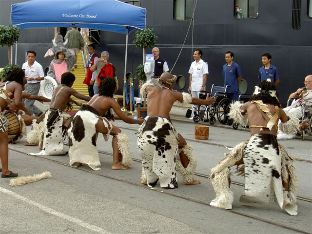
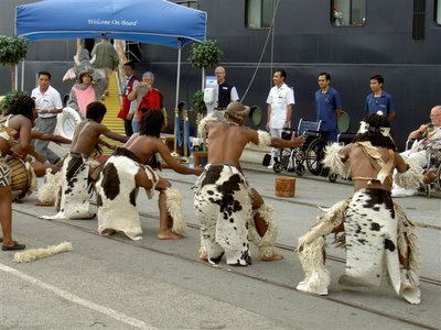
Today we are in Port Elizabeth which is a much smaller town and less Dutch, more English. This used to be part of the Zulu land. I think that smaller towns seem a little more manageable when you are a first time visitor. We were greeted by an African dance troupe who were so acrobatic, fueled only by the music of their drums. Alemitu found this sound rather comforting.
Then we were off on a bus to the Addo Elephant Game Park. This landscape was initially more green than in Cape Town. There are orchards of oranges, more of the sad looking slums or townships, but these seemed to offer a little more hope. Our guide told us that the government considers that education is the only way out of this mess, so they started by building new schools. Then gradually they and the inhabitants are building new homes. It was interesting to see cinderblock houses right next to the old shacks.
The game park was very hot and our bus was not air conditioned except by the wind. We were able to see several herds of elephants at their watering hole and see the families take care of their little ones. We sat there for about ½ hour just watching them bathe in the water. They were carefully joined by several warthogs and they babies. We also were lucky enough to see several ostriches and then a kudu. It was funny because I saw the kudu at the same time as the guide, but I honestly didn’t know what to call him, so I just pointed and dredged up a name from Kenya – élan. I guess I was close, but it is sad that so many words and names are forgotten when they aren’t used. We saw prickly-pear cacti and aloe vera plants (huge compared with what we have in the States), so you can guess that the climate is hot and dry. I’ll leave the rest for Alemitu.
Winnie
Winnie is a hard act to follow. Ship has been quiet medically speaking, and we are all waiting for the shoe to drop…so to speak. Mind you I am not complaining. It has given me the time to take a jillion pics and upload a few to our website here for y’all to read. South Africa has been a pleasant surprise for us and a very nice place to visit and tour in….not to mention getting medical consults on my tough patients and getting difficult medication refills. I am learning a lot about meds I don’t deal with in depth in my EM practice. It has been fun to get to know the crew through various social affairs on board, drills, and of course the crew only excursions. There are some very avid readers on board as well as more than a few folks who have been more places in their lifetimes than we have…which makes for some interesting conversations at breakfast. I love the smoked salmon and cream cheese with onions and capers every morning. I also appreciate not having to commute to work for 30 minutes but rather walking 10 steps across the hallway to my office….Such a Chore!
Looking forward to seeing Mombassa, Kenya again after almost 30 years….My how time flies when you are having fun! Hope your weather is looking up as it appears we took a good year to spend the winter in the southern hemisphere….You know how Winnie and I try to hide from the sun. Miss you!
Carter
February 23, 2006
The Afrikaners of South Africa
Afrikaners are South Africans of Dutch or French Huguenot descent that were known primarily as Boers, from the Dutch word for farmer. Afrikaners make up approximately 56 percent of South Africa’s white population. The first Afrikaners were Dutch pioneers who settled in 1652 in what is now Cape Province. Their language, customs and religion were shaped by more than three centuries of harsh frontier life. They intermarried with French Protestant (Huguenot) refugees to create the early Boer population. When the British occupied South Africa in 1795, many Boers refused to live under British occupation. During the 18th and 19th centuries, Afrikaans-speaking frontiersmen pushed into the interior, fighting both their Bantu neighbors and the British. These migrations, known as ‘the Great Trek’, were undertaken from Cape Colony into the interior beginning in 1835 and lasting into the 1840s. The participants moved inland by ox-wagons, settling and establishing two independent states, the Transvaal and the Orange Free State. After the Afrikaner defeat in the Second South African War (1899-1902), the British annexed these territories, and in 1910 the Union of South Africa was formed. Politically, the Afrikaners played a secondary role to the English-speaking South Africans until 1948, when the electoral victory of the Afrikaner National Party institutionalized Afrikaner political supremacy.
Port Elizabeth
February 22, 2006
Welcome to Port Elizabeth, South Africa
Port Elizabeth is situated in the Eastern Cape Province of South Africa. The city is located on Algoa Bay, and is one of the major seaports in South Africa. Port Elizabeth, often shortened to PE, and nicknamed The Friendly City was founded in 1820 by Sir Rufane Donkin, the Acting Governor of the Cape Colony, and populated with 4,000 British settlers arriving by sea. The new seaport town was named after Donkin’s late wife, Elizabeth. (It was not named for Elizabeth I as many people claim). The British built a concentration camp here during the Boer War to house Boer women and children. In 2001, the Nelson Mandela Metropolitan Municipality (NMMM), or Nelson Mandela Metropole, was formed by joining Port Elizabeth with the neighboring towns of Uitenhage and Despatch and the surrounding agricultural areas. Port Elizabeth is just south of the expanding Addo Elephant National Park, and boasts the highly successful University of Port Elizabeth (to be merged with PE Technicon in 2005 to form Nelson Mandela Metropolitan University). The furthest death attributed to the 2004 Indian Ocean Tsunami occurred on 26 December 2004 at Blue Horizon Beach, outside Port Elizabeth, 5,000 miles (8 000 kilometers) away from the source of the earthquake that caused the giant wave. The epicenter of the earthquake was below the sea, off the western coast of northern Sumatra, Indonesia.
Heading North

February 20, 2006 Cape Town, South Africa
Early in the morning on the 18th about 3am most of us (not Carter, and Alemitu was still awake) were awakened by very rough seas. We were coming around the Cape of Good Hope or the Cape of Storms as it used to be called. When the Atlantic and the Indian Oceans come together, it can be rough.
Then the next thing you knew (6am) we were entering the bowl that Cape Town is in. It was a sunny, beautiful day and all the mountains were out. Since this was our 1st view of Cape Town we didn’t realize that often the mountains are hidden, much like Mt. Rainier. Again, this is a huge city, but it is known as the Rainbow City because there are so many different races, mixed marriages, etc. We have been hearing a little about the history of the area, but the lectures stopped around 1900, so our understanding is incomplete.
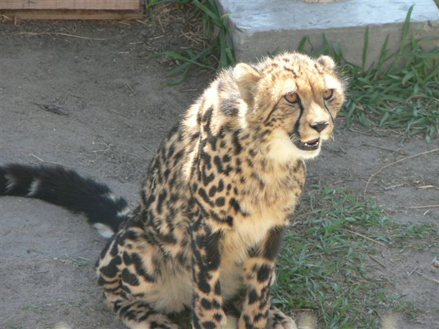
The 1st afternoon we were here (the 18th) we spent on a tour of a town northwest of here that is known for their wine. The town Stellenbosk is a university town which conducts its entire university in the Afrikaner language. They have all their textbooks in English but the lectures are in another language. The town was built by the Dutch, the wine-producing vines brought over by the French, so the photos look as though they were taken in Europe. The land was surprising by its lack of water. I thought it would be lush, but it was arid. The dividers on the road are filled with beautiful flowers which are natural insect repellent – amazing! On the tour we also saw a Cheetah rescue center and then went for wine tasting. I’ll let Alemitu fill you in on that.
The ride back was disturbing because we passed several townships which were the required living places for blacks during the last century. It was astounding to see 25 square kilometers of slums. They said that one of them would house approximately 1 million people. The toilets were along the perimeter and were just outhouses. They said that no city police will enter there and that most of the crime is dealt with by a kangaroo court. There is electricity but it must be purchased and since over 50% of the population is unemployed, not everyone can have it. On top of that there are periodic power outages, such as all of yesterday, so even if you pay for it, it might not be there for you.
The 19th we were awakened by some harbor seals who are very loud and playing right next to the ship. They lie in the sun, then slide off into the water to cool off. They certainly have a nice life of leisure.
Winnie
From Alemitu:
Hello everyone? Well we are now in Cape Town, South Africa. This place was not what I had expected to see, it looks developed where I am it doesn’t look like the kind of poor place I thought it would be. This place has a lot of European style here everyone one here dresses fancier and hip. A lot of the things here is very expensive if you want to buy any sort of souvenir. One the first day we were here we went on a tour to see some cheetahs and also to wine tasting place. The cheetahs were very cute to look at and if you pay money you could go in to their huge open pens to pet them. It was a little bit smelly around there because I think the cheetahs had just pooped or something. After taking some pictures we decided to get together with the group to go to the wine tasting building. When we got to the wine tasting room there were all these different kinds of wines in wine glasses wait for us to drink them. We all sat down and the wine tour leader was telling us about each of wine and what kind of food you could have food goes with the wine and what meal you can have the different wines with. I got to taste all of the different kinds of wine but I really didn’t like most of them except the red wine. Dad was sitting next to me and he was drinking all of his and than he reached on to my side and took the wine I had tasted and did not like and drank it and didn’t leave anything, I guess he liked that wine. After that experience we headed back to our ship but on the way there the tour guide was telling us about the places we were passing and one of the places we passed was a huge populated area of the poor and their living condition. Their houses were ready to fall apart and it was made out of corrugated tin. The houses were all close together. The houses looked so bad that you could not believe across the highway many modern and rich looking houses were there. While we were passing the poor part of the township some of the houses I was looking at reminded me of the houses in Ethiopia. While was looking at the poor houses it made me so sad to look at how they were living because that’s how I use to live before I came to America.
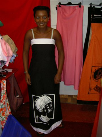
Yesterday mom and I decided to go shopping in the big mall that reminded me of the Bellevue mall in Seattle. I was so excited to be shopping that I went into this store and was looking at a very expensive but very cute dress and when I had entered the lady in the front desk looked at me very strangely, but I decided to ignore it and kept shopping. Later mom comes in and tells me if I am finished looking at the dress and I say yes but I like it very much can we come back later? Mom says ok but she tells me to look at the sign on the door of the store which says “Right of Admission Reserved”, which means that black people could not shop there. It made me so sick to my stomach that I didn’t want to shop any more and wanted to leave. I did not go back to that store like I had wanted to before. Every time we would go in to a store in that mall I would try to look on the doors to see if there are signs telling me I could not enter. It was the most uncomfortable feeling ever it made me angry and really depressed that they were still trying discriminate against the African people. Mom took me to another store and that was cheaper and got me happy again and I found one dress there which was very cute. I am so glad that mom was there with me shopping.
Well until next time always,
Alemitu
February 21, 2006
Explorations Speaker Ambassador Howard K. Walker
Ambassador Howard K. Walker’s 33-year diplomatic career included missions in Africa, the Middle East, Europe, Asia, and Latin America. He was Ambassador to three countries (Madagascar, Togo, and The Federal and Islamic Republic of Comoros) and Acting Ambassador in South Africa and in Tanzania. In Washington, he was Director of a State Department office that was responsible for formulating U.S. foreign policy in 17 countries. He led State Department teams to evaluate and improve the performance of American embassies and other State Department operations in France, Italy, Japan, Pakistan, Mexico, Hong Kong, Zambia, and Cuba. He was the State Department’s Senior Official (Vice President) of The National Defense University in Washington where he was responsible for ensuring that America’s future Generals and Admirals understand the diplomatic dimension of military actions. As Deputy Commandant of The NATO Defense College in Rome, he directed planning of the diplomatic-military curriculum for future military and civilian leaders of the American-European alliance. Following his diplomatic career, Ambassador Walker, who has a Ph. D in Government and Economics, has written about foreign policy matters for newspapers and journals. In retirement, he has taught on international relations and diplomacy at universities in Washington, Rome, Cape Town, and Stellenbosch. He and his wife, Terry, live in Chevy Chase, Maryland; Waterville Valley, New Hampshire; and Cape Town, South Africa.
fine south african wine tasting and lecture
At 2:00 pm in the Queen’s Lounge, join Jacques Vandewalle for a complimentary wine tasting; he has personally selected some of the best wines in South Africa, coming from ten different wineries. Today’s wine tasting will focus on white wines – from Sparkling to Noble Late Harvest. Mr. Vandewalle was born in 1956 to French speaking Belgian parents in the Belgian Congo and moved to Cape Town when he was 4 years old. He started in the wine business on the technical side some 30 years ago and is still with the same company, now called Distell – South Africa’s largest liquor producer and marketer. He now runs the Bergkelder Mountain Cellar in Stellenbosch, which also houses a unique wink bank called Vinoteque, where most of the wines being presented today have been drawn from this wine bank.
February 19, 2006
Early Cape Town History
The area today known as Cape Town was settled by the San and Khoikhoi, collectively known as the Khoisan, long before the Dutch East India Company (Vereenigde Oost-Indische Compagnie, the VOC) established a supply depot in Cape Town in 1652. By and large the indigenous people refused to deal with the Dutch, so the VOC imported slaves from Madagascar, India, Ceylon, Malaya, and Indonesia to deal with the colony's chronic labor shortage. There was also a shortage of women in the colony, so the Europeans exploited the female slaves for both labor and sex. In time the slaves also mixed with the Khoisan. The offspring of these unions formed the basis of sections of today's Cape Colored population and also helps explain the unique character of the city’s Cape Malay population. During 150-odd years of Dutch rule, Kaapstad, as the Cape settlement became known, thrived and gained a wider reputation as the “Tavern of the Seas”, a riotous port used by every sailor traveling between Europe and the Orient. But, by the end of the 18th century, the VOC was nearly bankrupt, making Cape Town an easy target for British imperialist interests in the region. Following the British defeat of the Dutch in 1806 at Bloubergstrand, 25 kilometers north of Cape Town, the colony was ceded to the Crown on 13 August 1814. The slave trade was abolished in 1808, and all slaves were emancipated in 1833.
cape town’s 19th and 20th century history
Bubonic plague in 1901 gave the government an excuse to introduce racial segregation: Africans were moved to two locations, one near the docks and the other at Ndabeni on the western flank of Table Mountain. This was the start of what would later develop into the townships of Cape Flats. In 1948, the National Party stood for election on its apartheid policy and won. In a series of bitter court and constitutional battles, the limited rights of blacks and colored to vote in the Cape were removed, and the apartheid was erected. This resulted in whole communities being uprooted and cast out to the Cape Flats. The government tried for decades to eradicate squatter towns. In the last attempt between May and June 1986, an estimated 70,000 people were driven from their homes. But this attack was unsuccessful in eradicating the towns, and the government accepted the inevitable and began to upgrade conditions. Hours after being released from prison on February 11, 1990, Nelson Mandela made his first public speech in decades from the balcony of Cape Town’s City Hall, heralding the beginning of a new era for South Africa. Much has improved in Cape Town since; property prices are increasing greatly and the city centre is becoming safer, with the development of loft-style apartments in grand old structures such as the Old Mutual Building and the Board of Executors building. Full integration of Cape Town’s mixed population, however, remains a long way off, if it is achievable at all. The African National Congress (ANC) and the New National Party (NNP) are working together on the City Council, which is headed up by mayor Nomaindia Mfeketo, a black woman.
Women Unite
This all women, Guguletu based group is taking the traditional dance and music scene by storm. The dancers in this group all have previous experience from different dance backgrounds from ballet to ballroom, and have used this to create the vibrant, energetic and slick dance group that it is today.
February 18, 2006
Welcome to Cape Town, South Africa
Cape Town is the third most populous city in South Africa and its legislative capital as well as capital of the Western Cape province. The city lies at the foot of Table Mountain (3,570 feet, 1,090 meters), so named after its flat top, and on the shore of Table Bay. Cape Town is a commercial and industrial center; oil refining, food, chemical, and fertilizer processing, and the manufacture of automobiles, leather and plastic goods, and clothing are the chief industries. An important port, Cape Town exports mainly gold, diamonds, and fruits. With one of the world’s largest drydocks, ship repairing is an important industry. Cape Town is famous for its gorgeous natural harbor, as well as its location near the Cape of Good Hope. Much of the former dock area is now a commercial and tourist waterfront area with museums, craft markets, and restaurants. Because of its location and natural beauty, Cape Town is the tourism capital of South Africa, receiving the largest number of tourists of any South African city. The area is also famous for its unique plant life: fynbos (an Afrikaans word meaning “fine bush”), a shrubby vegetation type similar to other winter rainfall shrublands, in which proteas are prominent and characteristic Lastly, it is famous for the fine wines produced in the areas of Stellenbosch, Paarl and Robertson.
table mountain
Hike up Table Mountain for an unforgettable view. The cable car is such an obvious and popular attraction you might have difficulty convincing yourself that it’s worth the trouble and expense… it is. The views on the way up and from the top of Table Mountain are phenomenal, and there are some good easy walks on the summit. The mountain is home to over 1400 species of flowering plants. For an adrenalin rush like no other consider doing the abseil. It’s also possible to walk up the mountain from either the City Bowl side or the Kirstenbosch Botanical Gardens side.
wine country
The oldest vineyards in the world, outside of Europe and the Middle East, are in South Africa. Since 1659 grapes have been pressed at the Cape and several of today’s top wine estates have been producing wine for more than 300 years. Today there are over 2100 different wines to choose from in South Africa. Most of the wines made are white wines in the German style from dry to semi-sweet. One characteristic of South African wines is the higher alcohol content due to the sunny climate. Apart from these white table wines, there are exceptional sherry-style wines. Cabernet Sauvignon is the best red wine followed by Shiraz, Pinot Noir, Merlot and many blends of these. A crossing of Pinot Noir and Cinsaut was invented in the Cape and made headlines in 1959. This richly flavored, full-bodied wine, called Pinotage, is at its best after at least ten years’ bottle maturation, as is an absolute must for the discriminating connoisseur. Until recently, South African wines have been a relatively well-kept secret. Now, with increasingly positive competitive exposure and a growing reputation among travelers and wine connoisseurs, these wines are building a world-class stature. Strict control is exercised by inspectors to ensure that what’s on the label is definitely what’s in the bottle. Wines carry a small ‘Wines of Origin’ sticker on the neck of the bottle, which tells if the label has been certified for a particular type of grape, a particular year, or a particular wine region. Colored horizontal stripes – green, red, and blue – relate the information. A wine can be certified for any one of these descriptions or all three.
February 17, 2006
Executive Chef Ed Sayomac
Executive Chef Eduardo Sayomac is truly a Holland America Line product! Hailing from the beautiful islands of the Philippines, Ed joined Holland America Line in 1981 as a General Purpose Assistant Pantry. GPA Pantries work in all areas of the kitchen, from serving food in the Lido, to preparing room service short orders to cutting fruit and serving ice cream. Having worked his way up, sailing on every single DAM ship in the fleet and learning all the different parts of the galley, Ed’s favorite part of the job to this day is to watch the smile he can bring our guests each time he creates something special that they’ve never seen or tasted before. About 20 years ago, an Executive Chef, recognizing Ed’s culinary talents said, ‘One day you will sit in this chair.’ Ed laughed when he heard that at that time, but the prodigious statement came true when he accepted the position of Executive Chef onboard the old Westerdam in 2000 - much to the good fortune of every guest who enjoys the fruits (not to mention the vegetables and entrées) of his gifted labor in our dining rooms every evening. He is also a member of an elite group of chefs from around the world, the prestigious Chaîne de Rotisseurs. Ed met his wife Helen, a former shop attendant, while sailing the seas for Holland America Line. Ed, Helen and their 15-year-old son, Aaron Edward, reside in their family home in Leicester, England. Ed’s hobbies include cooking and soccer, although he does not practice the two at the same time, he hastens to add.
explorer david livingston
David Livingstone, 1813 – 1873, was a Scottish missionary and explorer in Africa and the first European to cross the African continent. From 1841 to 1852, while a medical missionary for the London Missionary Society in what is now Botswana, he crossed the Kalahari desert and reached Lake Ngami in 1849. He discovered the Zambezi River in 1851. Hoping to abolish the slave trade by opening Africa to Christian commerce and missionary stations, he traveled to Luanda on the west coast in 1853. Following the Zambezi River, he discovered and named Victoria Falls in 1855 and reached the east coast at Quelimane, Portuguese East Africa (now Mozambique), in 1856. His Missionary Travels of 1857 in South Africa is an account of that journey. Appointed British consul at Quelimane, he was given command of an expedition (1857 – 1863) to explore the Zambezi region. In 1866 he returned to Africa to seek the source of the Nile. He discovered lakes Mweru and Bangweula and in 1871 reached the Lualaba tributary of the Congo River. Sickness compelled his return to Ujiji on Lake Tanganyika, where the journalist H. M. Stanley found him in 1871. Unable to persuade Livingstone to leave, Stanley joined him on a journey from 1871 – 1872 to the north end of Lake Tanganyika. In 1873 he died in the village of Chief Chitambo.
February 15, 2006 South Atlantic, on the way to Cape Town, South Africa
Yesterday we dropped anchor near Tristan da Cunha, and glory be, they allowed those physically able to go ashore, excluding crew. So, we didn’t get a chance to touch land, but we were able to entertain the local doctor and his family, which was informative and gratifying. Quite truthfully, I have missed being around children more than I thought I would. This family is doing a locums here for 3 months. They are from rural South Africa, so the “wilderness medicine” they are practicing isn’t that different. He is the only physician and also has to act as the dentist since the dentist only comes every 6 months. That, he says, is stressful. They have 3 sons who savored the pizza, ice cream and popcorn on the ship, as well as having a wise mother who brought along swim suits, so they were able to join the captain’s daughter (age 7) in the pool. It was fun to watch.
The island of Tristan da Cunha has such interesting rules. They have 264 inhabitants and only those born on the island are able to live there –other than those who marry in. Medical emergencies have to wait up to 7 days for a ship to come to get them, and then they need another week to get to So. Africa. The people live primarily on fish and potatoes which they catch or grow. They get a food and natural gas shipment from South Africa every couple of months, but sometimes they are not able to be delivered because of the weather. Their previous pier was destroyed by lava during an eruption of their volcano, so their present pier is rather precarious and not good in high seas or inclement weather. There is a US researcher on the island studying the rodents and the birds. Most of the birds are in decline because they are burrowing birds (there are not any trees) and the rats and mice are eating the eggs and even the chicks before they fledge.
Now we are on the way to Cape Town where we will be for 3 days. I have walked around the deck so many times that I will be thankful for different scenery. We are also beginning to feel the “small town” of being on a ship. Last night there was a Valentine’s party given by one of the guests and an older woman cornered me, telling me all sorts of things I didn’t need to know. She told me who had had a good face lift and those who had botched jobs, and who was going on the cruise next year and who is being a pill on the ship. It went on and on. I’ll have to make sure I am a neutral being from now on….. Winnie
Bull Family at Tristan da Cunha

February 14, 2006
February 13, 2006 South Atlantic, on the way to Tristan da Cunha
The sea has changed from a green color to a glorious blue. The temperature has been rising and we only need a light jacket when out on deck. People are starting to get a little stir crazy since we haven’t seen much land for the last 10 days. Alemitu is a regular shuffle board player with other passengers and today as I was walking the deck for exercise I heard several older people asking, “Where’s Ali? We need her on our team.”
Alemitu has also become friends with the young man who makes the popcorn before each movie. She will often stand around and talk with him while waiting for the movie to start and will become the door-opener for the passengers coming to the movie. One evening when she wasn’t there, passengers were asking for her.
We are cruising thru the South Atlantic and because we are so low on the globe, we are going thru the time zones lickety-split. We have had 2 in the last 3 days and have 2 more in 2 days. I require naps more frequently.
Winnie
Parked off Tristan da Cunha today(Sunny) which is is the middle of the South Atlantic. A small group of volcanic islands occupied by 270 English inhabitants, it is a beautiful place with green everywhere. Only one small flat place with picturesque homes and small vegetable gardens. Almost no harbor or beach front to allow for easy tender or boat access. We have had the So African physician (Alastair and Fiona Bull) and his family of 4 (3 young sons) join us this am on board and they loved the ship and its amenities (swimming pools) and the ice cream bars. I believe the grandparents on board loved seeing them even more though. Have seen 2 accidents already related to falls from the exiting of the zodiacs in the ocean swell. Best Wishes!
Carter
February 16, 2006
Food & Beverage Manager John Leitao
I was born in Goa, moved to Europe and then to Canada. I have completed my Hotel Management and have worked for 5 star chain of Hotels around the world for the past 15 years. I had always dreamt of working for a Cruise Line. Although the interview process was hard and lengthy, eventually got an opportunity to work for an esteem organization of Holland America. In 2003I started as an Assistant F& B Manager on Ms. Amsterdam and was recently promoted to a F&B Manager's position at Ms. Prinsendam. During my tenure with Holland America, I have also worked on Ms. Oosterdam, Ms Ryndam, Ms. Maasdam, and Ms. Westerdam. I feel privileged to be doing the GRAND VOYAGE- The Circle of the Sun.
explorer david livingston
David Livingstone, 1813 – 1873, was a Scottish missionary and explorer in Africa and the first European to cross the African continent. From 1841 to 1852, while a medical missionary for the London Missionary Society in what is now Botswana, he crossed the Kalahari desert and reached Lake Ngami in 1849. He discovered the Zambezi River in 1851. Hoping to abolish the slave trade by opening Africa to Christian commerce and missionary stations, he traveled to Luanda on the west coast in 1853. Following the Zambezi River, he discovered and named Victoria Falls in 1855 and reached the east coast at Quelimane, Portuguese East Africa (now Mozambique), in 1856. His Missionary Travels of 1857 in South Africa is an account of that journey. Appointed British consul at Quelimane, he was given command of an expedition (1857 – 1863) to explore the Zambezi region. In 1866 he returned to Africa to seek the source of the Nile. He discovered lakes Mweru and Bangweula and in 1871 reached the Lualaba tributary of the Congo River. Sickness compelled his return to Ujiji on Lake Tanganyika, where the journalist H. M. Stanley found him in 1871. Unable to persuade Livingstone to leave, Stanley joined him on a journey from 1871 – 1872 to the north end of Lake Tanganyika. In 1873 he died in the village of Chief Chitambo. African followers carried his body to the coast where it was sent to England and buried in Westminster Abbey.
February 15, 2006
Explorations Speaker Mike Millwood
Mike Millwood was born in London, England, with the sound of Bow Bells, making him a true ‘cockney’. He survived the German bombing of that city and at the end of the second World War attended Grammar School and won a state scholarship to study at London University, where he obtained an Honors Degree in International History. He undertook post-graduate studies at Nottingham University and then entered the teaching profession. He taught in several high schools, eventually becoming head of a history faculty and receiving his Master’s Degree from Leicester University. In 1965 he became a senior lecturer at Kesteven College, a part of Nottingham University, and it was here that he met his wife Lyn. Shortly after their marriage he accepted a post to be the first principal of the Menai Center, a short-term residential education facility in Wales. In 1990 he decided to accept a post as Principal Examiner in History at Cambridge University’s Local Examinations Syndicate. Mike was awarded a Residential Fellowship at Liverpool University during a sabbatical in 1985 and in 1992 he gained a Traveling Scholarship to Japan awarded by the Daiwa Anglo-Japanese Foundation. In 1997 Mike and Lyn made the decision to emigrate to Arkansas become U.S. citizens. Mike now teaches history on a part-time basis at the National Park Community College in Host Springs. In the summer of 2002 he was awarded a National Endowment for the Humanities Bursary to be visiting Scholar at the University of Southern California.
explorations speaker series lectures
Join Explorations Speaker Mike Millwood at 11:00 am in the Queen’s Lounge for his lecture Dutch Settlements in South Africa – and the British Takeover, 1814. Come hear how the beautiful port of Cape Town was first developed by the Dutch in the 17th century and the reasons for this. The subsequent British capture of Cape Colony and the payment made to the Dutch will also be examined. Then, at 2:00 pm in the Queen’s Lounge, John Splettstoesser presents Penguins and Rocks – how they coexist and leave evidence useful for sea-level studies. Learn how Rockhopper penguins and some other species have the ability to leave traces of their presence in the rocks.
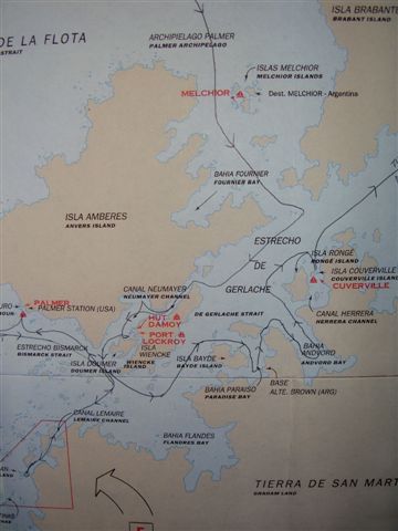
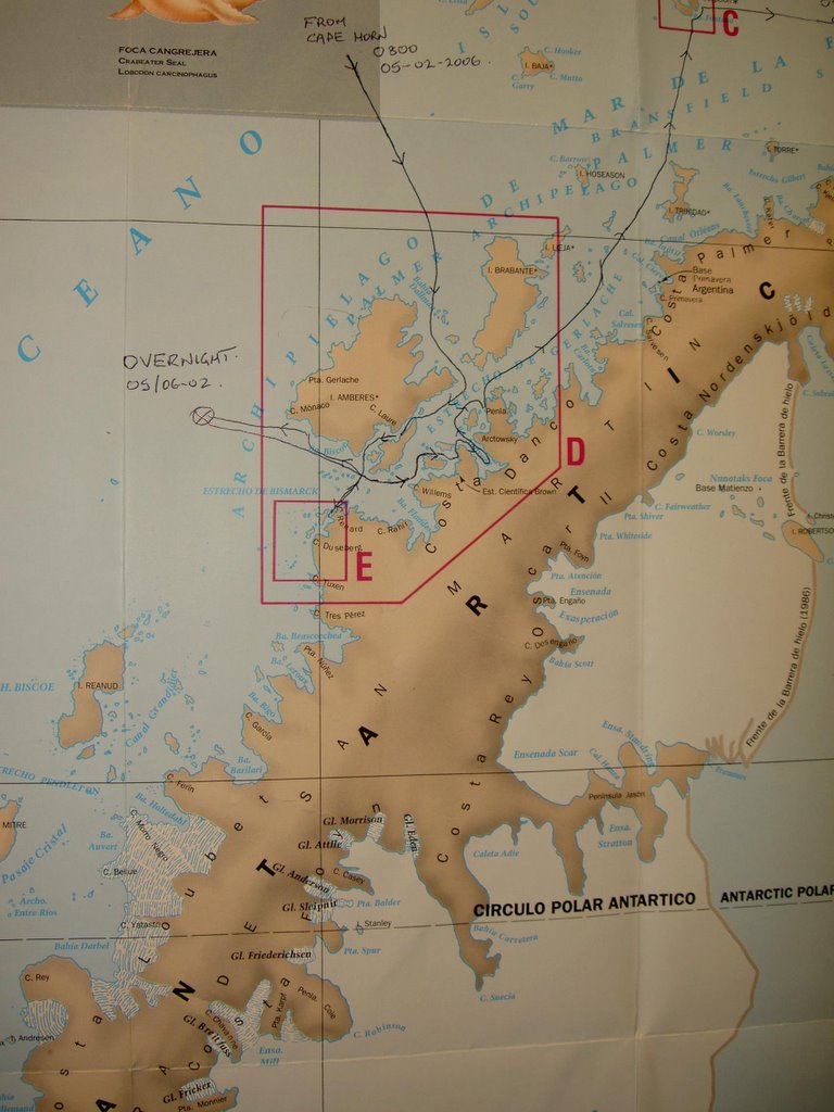
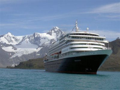
South Georgia/Grytviken
Views from South Georgia and Sunrise at Sea
Febraury 13, 2006
Chief Housekeeper Willem Regelink
Born in Zwartsluis, the Netherlands, but for the past ten years has lived in Thailand, Willem Regelink is now the Senior Chief Housekeeper for the Holland America Line fleet. His career with the company began in 1969 when he joined the old… old Nieuw Amsterdam as an Assistant Cabin Steward; back then, every night was a formal night except for Sunday, so people traveled with a lot more luggage then they do now! Despite having to share a room with eight other crewmembers, his passion sparked through and his enthusiasm and zeal for his job has never stopped. ‘You have to like people to do this job, that is something you cannot fake!’ Working his way up the proverbial ladder, Willem was promoted to the position of Chief Housekeeper in 1979/1980. He currently manages a department of 70 of the hardest working staff on board any cruise ship, all of them working around the clock keeping the ship clean and up to our ‘Tradition of Excellence’ standards, reiterating the verity that Holland America Line is the ‘spotless fleet’. 2005 marks Willem’s 33rd Grand World Voyage and his 36th year with the company. His favorite part of his job is to take care of special requests, going out of his way to provide extra and exceptional service to all of our guests. The lifelong friends he has made with the guests who have sailed with him for many years on various Holland America Line ships is something that Willem will always cherish and what drives him to make his time with the company phenomenal for everyone.
February 12, 2006
Environmental Officer Jan Jacob Westerbeek
Jan Jacob Westerbeek was born October 16, 1951 onboard the mv Catharina; his parents have their own shipping company, which has been a family tradition since 1764. He attended boarding school in Rotterdam and sailed as Mate and Master (1967 - 1970) on inland water and coastal cargo vessels during his days and weeks off. After finishing high school, he attended the Royal Dutch Navy to be a nautical officer and left the Navy after a couple of years and studied Civil Engineering at Delft University. He could not forget ships and shipping and started working with Damen Shipyards handling special projects in The Middle East, like the delivering and commissioning of many special vessels to customers in the Middle East. Jan married his wife Marrie in 1986 and has 3 beautiful children: 1 girl (Marjon) and 2 boys (Jan & Jeroen), now 18, 16 and 13 years old. During a period of 4 years, he managed a shipping company as Manager Director but could not forget real sailing and left Seatrade Groningen and started freelance navigating again as Nautical Officer, Mate and Master. In 1997 he did additional studies for his master license square-riggers and made from a long lasting hobby a profession during off periods. He joined Holland America Line in 2004 as an Environmental officer. Hobbies are still sailing on large sailing vessels (Square riggers) and when at home fabricating sea chests from teak wood and building nice constructions in the garden for wife and children.
explorations speaker
series lectures
Join Explorations Speaker Dr. Bernard Stonehouse at 10:45 am in the Queen’s Lounge 8 for his lecture entitled Shackleton – Extraordinary Leader and Explorer. It is a review of one of the more famous explorers, being an account of his spirit and leadership of his men and never having lost a man under his direct command.
q & a with dr. mae jemison
Her amazing life is an inspiration to many and her accomplishments are second to none. At 2:00 pm in the Queen’s Lounge 8, join Dr. Mae Jemison for a questions and answer session hosted by your Cruise Director Bruce.
February 11, 2006
Explorations Speaker Dr. Mae Jemison
Mae C. Jemison blasted into orbit aboard the space shuttle Endeavour, September 12, 1992 – the first woman of color to go into space. Now, founder and president of two technology companies, the space flight was just one of a series of accomplishments for this dynamic woman. Born in Decatur, Alabama and raised in Chicago, she entered Stanford University as a scholarship student at age 16. After graduating with a B.S. in Chemical Engineering and an A.B. in African and Afro-American Studies, she earned her doctorate in medicine at Cornell University Medical College.
Prior to her six years as an astronaut (1987-1993), Dr. Jemison served two and a half years as the Area Peace Corps Medical Officer for Sierra Leone and Liberia and practiced medicine in Los Angeles. After NASA, she founded the technology consulting firm, The Jemison Group, Inc., to consider socio-cultural impacts when designing technologies. As an environmental studies professor at Dartmouth College, she taught courses on sustainable development and technology design. Her latest business venture, BioSentient Corporation, focuses on physiological monitoring to improve health and human performance. A strong, committed voice for science literacy, in 1994 Jemison founded the international science camp The Earth We Share™ for students 12-16 years old. In her book Find Where the Wind Goes, she writes for teenagers about growing up on the south side of Chicago, cultivating her aspiration to be a scientist and professional dancer, her experiences as a medical student in Africa, and her history-making journey into space. An A.D. White Professor-at-Large at Cornell University and a member of several Fortune 500 corporate boards, Jemison is a member of the Institute of Medicine, an inductee of National Women’s Hall of Fame and the National Medical Association Hall of Fame, and winner of the Kilby Science Award. In 1993 she was chosen one of People Magazine’s “World’s 50 Most Beautiful People” and in 1999 she was selected as one of the top seven women leaders most likely to become President of the United States.
from the navigator
After departing Cumberland Bay and Grytviken, we proceeded on a northeasterly course in the South Atlantic Ocean on our way to Tristan da Cunha. Both the ocean currents and the prevailing wind-system in this ocean region, and at this time of the year, are favorable for us and are with us in the same direction as our course-line.
February 9, 2006
February 10, 2006
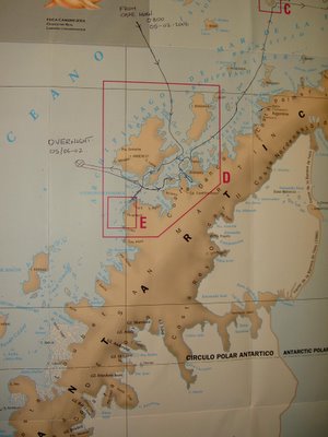
Welcome to Cumberland Bay, South Georgia
Cumberland Bay was discovered and named in 1775 by a British expedition under James Cook. It is 4 miles (6 kilometers) wide at its entrance between Larsen and Barff Points, which separates into two extensive arms that recede inland along the northern coast of South Georgia. South Georgia lies in the South Atlantic Ocean east of the Falkland Islands. It has a land area of 2116 square miles (3528 square kilometers) including satellite islands, but excluding the South Sandwich Islands, which form a separate island group. It is mountainous, with 11 peaks over
6600 feet (2,000 meters) their slopes furrowed with deep gorges filled with glaciers (Fortuna Glacier being the largest). Geologically, it consists of gneiss and argillaceous schists, with no trace of fossils, showing that the island is a surviving fragment of some greater land-mass now vanished, most probably indicating a former extension of the Andean system. The German expedition sent out to observe the transit of Venus was stationed at Royal Bay, on the southeast side of the island in 1882. The climate in the islands is variable, with mostly westerly winds throughout the year interspersed with periods of calm; nearly all precipitation falls as snow. Most of the islands, rising steeply from the sea, are rugged and mountainous; South Georgia is largely barren and has steep, glacier-covered mountains; reindeer, introduced early in the 20th century, live on South Georgia.
south georgia history
The island was first sighted by a London merchant in1675 and was named Pepys Island in 1684. Captain James Cook rediscovered it in 1775. Throughout the 19th century it was a sealers’ base and, in the following century, a whalers’ base until whaling ended mid-century.
important south georgia tour regulations
∙ All tours will dispatch from the Wajang Theater 8
∙ There are no restrooms ashore.
∙ Smoking is strictly forbidden on the island.
∙ Food is strictly forbidden to be taken ashore.
∙ Guests are not allowed to stray from the designated group and group leader.
∙ Guests are not allowed to go ashore unless participating on an organized complimentary tour.
∙ Should you take water, you must bring back your water bottle.
∙ Do not litter the island.
∙ Rocks, plants and artifacts should not be touched.
∙ Groups must stay at least 5 yards clear of all wildlife
If the weather turns unexpectedly worse the following precautions must be taken:
∙ Every guest should take with them 3 days worth of medication.
∙ It can be extremely cold, windy and possibly wet. Wear warm, waterproof clothing and good footwear.
∙ At any time due to a sudden change of weather the tenders may stop operating.
Wish me luck I'm not stranded there for the nex three days!
Carter
February 9, 2006
Fresh Produce Aboard the ms Prinsendam
Did you know the berries you’ve been enjoying are also first class frequent flyers? In order to ensure the freshest possible fruits, berries and lettuce we use high-tech sealed temperature controlled ‘EnviroTainers’ flown from Australia and filled with only the best possible produce to remote exotic ports of calls such as Samoa, Brunei, Seychelles and Mauritius. As many of the local ports we call in don’t carry the produce variety, quality or quantities needed on the ms Prinsendam. Additionally, many soft berries, fruits and vegetables have very short shelf lives or limited growing seasons – adding to the challenge of maintaining the fruits and vegetable selection throughout the World Cruise. Your culinary team works hard to plan these deliveries and overcome numerous logistical challenges so that even on long sea stretches we can make your favorite fresh berries and more be available.
February 8, 2006

I can’t believe I am getting to see Antarctica. I am seeing bunch of ice bergs that are so huge. There are so many penguins on the ice bergs that are floating by the ship. I also saw seals and sea lions just lying on the ice bergs together. There are many mountains in Antarctica; I didn’t think there would be mountains besides ice floes and enormous ice bergs. The first day in Antarctica was great because the sky was clear and we got to see all the sea animals and the birds. The last two days have been very foggy but you could still see land and some birds and penguins. Oh, I also saw three whales on the first day here. Right know we are just at sea on our way to South Orkney Islands. The waves that are hitting against the ship are so big that it is scaring the heck out of me.
I have also been walking 1 mile out on the deck around the ship in the freezing and windy weather. While walking I slipped and fell on my bottom it was really funny. I am trying to stay busy by talking to the crew workers and exercising or reading. The crew workers are very nice. There is a Java café that I go to and the guys that work there are very nice and they show me magic ticks so I can stay entertained and not get board on the ship. I am also eating a lot of food; right now I am trying to slow down so I won’t return like a whale.
Always, Alemitu
February 8, 2006
South Orkney Island
The South Orkney Islands are a group of sub-Antarctic islands situated southeast of Cape Horn in the South Atlantic Ocean. The archipelago comprises four main islands. Coronation Island is the largest island; its highest point is Mount Nivea and rises to 384 feet (1266 meters) above sea level. Laurie Island is the easternmost of the islands. The other islands are the smaller Powell Island and Signy Island as well as a few tiny ones named Saddle Islands. In total, these islands have a surface of about 372 square miles (620 square kilometers) most of which is covered with ice. The Inaccessible Islands about 15 nautical miles to the west are also considered part of the South Orkneys. The South Orkney Islands were discovered in 1821 by two sealers: the American Nathaniel Brown Palmer and the British George Powell. Powell named Coronation island thus because it was the year of the coronation of King George IV. He called the archipelago "Powell's Group". In 1823, James Weddell visited the islands, gave the archipelago its present name and also renamed some of the islands. Subsequently, sealers and whalers frequently visited the islands, but no thorough survey was ever done until the expedition of William Speirs Bruce on the Scotia in 1903, which over-wintered at Laurie Island.
Bruce surveyed the islands, reverted some of Weddell's name changes, and established a meteorological station, which was turned over to Argentinian meteorologists upon his departure in 1904. This station, renamed Orcadas in 1951, is still in operation today and is thus the oldest research station continuously staffed in the Antarctic. In 1908, the South Orkneys became part of the Falkland Islands Dependencies. The British Antarctic Survey opened a biological research station on Signy Island in 1947. Both the United Kingdom and Argentina make territorial claims on the South Orkneys, but as they are further south than 60°, the archipelago is subject to the Antarctic Treaty. Argentina refers to the islands as Orcadas Islands.
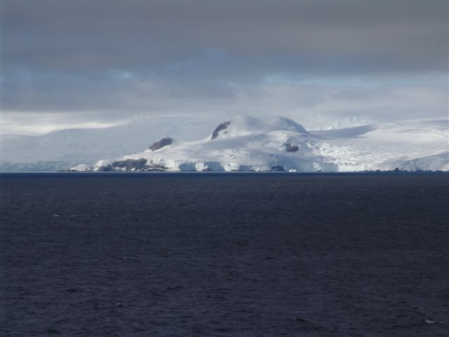
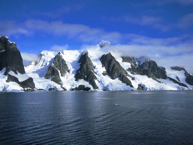
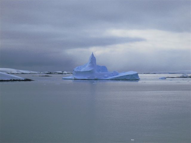
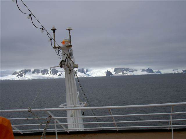
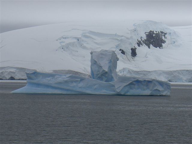
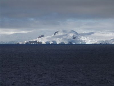
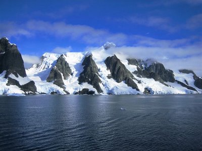
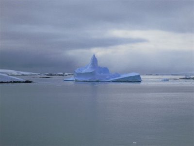
February 7, 2006 Antarctica
One passenger said that we don’t have the vocabulary to explain Antarctica. I think he is correct. I thought Glacier Bay in Alaska was amazingly beautiful. I never seemed to get enough of it. Well, this is 10 times that. The beauty never seems to end! When we first went to Alaska there were numerous animals on the icebergs. Over the years they have become a rarity. The reason has never been explained. Perhaps too many cruise ships, perhaps it is getting too warm. But that is not the case here. We encounter iceberg after iceberg, many of them covered with penguins or seals. The animals seem to be watching us as much as we are watching them. The penguins slide on their stomachs off the icebergs, then the scramble up again and take another look. The seals are often in groups which the commentator identifies as a male leopard seal with his “harem” and pups.
Carter has posted numerous photos, most of which were taken the first and second days. Today has been a disappointment because it started out foggy and has not improved much. We missed the anticipated “iceberg alley”, but I feel so lucky to have had 2 gorgeous days to see the wildlife and environment. We even saw an island that is too hot to touch with your bare skin because it is an active volcano. That just doesn’t seem right here in Antarctica. Alemitu is frozen and has mostly confined herself to the inside of the ship, whereas I finally feel good because it is cold. I brought my MN winter clothes and have enjoyed being out on the deck as much as I can.
The captain managed to find a satellite receptive area during the Super Bowl so we could watch that. Carter went for the first half, missing dinner in the dining room, to dine on hot dogs and hamburgers. He was frustrated because the only “fluids” were those for sale and the salty entrees made him thirsty – and of course, he wouldn’t cave to paying. We were sad for Seattle, but also proud that they were there in the first place.
Carter and the wine steward George now are torturing Alemitu with talk of an arranged marriage for her and his son. When Alemitu asked him if there was one thing that was a must, he said, “You have to be Catholic.” Well, that gave her an out! So then Carter began to negotiate for one of his sons with George’s daughter. Watch out, boys! But George continues to serenade her for his son, asking her if she would please look at her future father-in-law. She is embarrassed beyond belief – so they just keep playing along.
Winnie
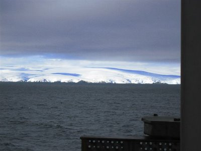
February 8, 2006
Foggy day in Antarctica and the ocean swell is picking up as well. We are heading northeast past Elephant Island, Hope Bay and then South Orkney Islands tomorrow. Hoping the radar works as we have seen some rather large and numerous icebergs out here. Am watching a passenger develop a foot ulcer which is slowly evolving before my eyes despite all my efforts to stop the progress and get it to heal. It is so frustrating for all involved. I am having to debride margins every other day and am clearly getting beyond my comfort zone. It is also frustrating not being able to obtain specialty consultation due to delayed and spotty internet availability due to satellite positioning. I hope she still has a viable foot when we arrive in Cape Town February 18, 2006.
Regarding our impressions of the last 3 days cruising in Antarctica; Pictures can’t completely describe the natural beauty and grandeur of the ice, sea birds, penguins, seals, and whales juxtaposed on fantastic basalt mountains jutting out the ocean covered with glaciers, blue ice, and so many hues of light and clouds. It is just so different than any other setting we have ever seen. Awe is perhaps the best word to describe it all!
Hope all is well at home with you all.
Carter
February 7, 2006
The International Geophysical Year
The International Geophysical Year (IGY), from July 1957, through December 1958, was planned to correspond with a period of maximum sunspot activity in Antarctica. As part of the IGY, 12 nations maintained 65 stations and operational facilities in Antarctica. The more difficult logistical problems of establishing inland bases were undertaken by the United States and the USSR. The American effort, termed “Operation Deep Freeze”, concentrated on the building of McMurdo Station, a major base of operations, on Ross Island; five other U.S. stations were established, including one at the South Pole. The Russians concentrated on east Antarctica, building Mirnyy, a station on the Queen Mary Coast, and three bases inland: Komsomolskaya, Vostok (at the South Magnetic Pole), and Sovetskaya. Britain maintained 14 stations, and Argentina, Chile, France, Australia, Belgium, Japan, Norway, South Africa, and New Zealand also participated. From 1951 to 1958, Dr. Vivian Fuchs led the British Commonwealth Trans-Antarctic Expedition's traverse with tractors from the Weddell Sea to McMurdo Sound via the South Pole, conducting a seismic and magnetic profile en route. Long-distance flights by U.S. planes covered 2,000,000 square miles (5,180,000 square kilometers) in 1955 to 1956. These and later support flights, the tractor journeys to build bases, and geophysical traverses by tracked vehicles during the IGY left little of the continent that had not been seen.
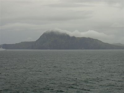
elephant island
Elephant Island is an ice-covered, mountainous island off the coast of Antarctica in the outer reaches of the South Shetland Islands. The island is approximately 6 by 1.2 miles (10 by 2 kilometers) long with a maximum elevation of 2795 feet (852 meters) above sea level at Pardo Ridge. The island supports no significant flora or native fauna although migratory Gentoo penguins and seals may be found on its shores, and Chinstrap Penguins nest there. The island is most famous as the refuge of Ernest Shackleton's crew in 1914 following the loss of their ship Endurance in Antarctic ice. Shackleton left his second in command, Frank Wild in charge of 21 men on Elephant Island for more than four months while he sailed across open ocean with five other men to South Georgia and led attempts to return with a rescue ship.
hope bay
Hope Bay is 3 by 2 miles (5 by 3 kilometers) indenting the tip of Antarctic Peninsula and opening on Antarctic Sound. Discovered on January 15, 1902, by the Swedish Antarctic explorer under Nordenskjold, who named it in commemoration of the winter spent there by J. Gunnar Andersson, S.A. Duse, and Toralf Grunden of his expedition. The British established a base at Hope Bay in 1945 as part of Operation Tabarin. On December 8, 1997 the British Antarctic Survey transferred the base to Uruguay, who renamed it Teniente Ruperto Elichiribehety Uruguayan Antarctic Scientific Station. The Argentine base Esperanza is also located at Hope Bay.
antarctic treaty & further research
The success of the International Geophysical Year’s effort led to the signing of the Antarctic Treaty in 1959 by representatives of the 12 nations that had been involved in the IGY. The treaty prohibits military operations, nuclear explosions and the disposal of radioactive wastes in Antarctica and provides for cooperation in scientific investigation and the exchange of scientific data. In 1991, 24 nations signed a protocol to the 1959 treaty barring for 50 years the exploration of Antarctica for oil or minerals. Of the 12 nations involved in the IGY, some have dropped their programs, others have suspended and then renewed operations; those that have been continually involved have reduced the size of their programs. Eighteen nations now operate more than 30 year-round research stations on the continent; many more are operated in the summer. At McMurdo the United States has built a scientific village where people may be housed in summer and winter. From McMurdo other U.S. bases are supported by air. The National Science Foundation finances the U.S. programs. Logistical support was in the hands of the U.S. navy until 1998, when air support was taken over by the New York Air National Guard. Mapping is done by
February 5, 2006
February 4, 2006
In the middle of the Drake Passage
One of our speakers told the perfect cure for seasickness: lie down flat under a tree. The room as silent for a moment, then followed by bursts of laughter.
Yesterday we were in Ushuaia, Argentina which is nicknamed “The End of the World”. It is the last city in South America. The landscape looked like Southeast Alaska with the clouds patched over the mountains, a little mist here and there, cool temperatures. It was beautiful. Plus all stomachs had returned to normal since the ship was docked.
Carter had signed us up for a Trek. There was no further explanation, so naturally, I began to worry. I knew that I would be the grande dame of this hike since it was crew only and I desperately didn’t want to embarrass myself. My worry was well-founded, but I survived and did NOT embarrass anyone, thank goodness. Kit had me well into a fitness routine and I have not missed a day of working out since the beginning of the cruise. We started out being taken by bus into the Tierra del Fuego National Park and walked for 3 hours. First we trudged thru peat bogs that went up to mid-calf of our Wellington’s. I did have a moment or two of stress when my boot became mired in the mess and I couldn’t extract it. It was sticky, brown and reminded me to quicksand. Of course, Carter and Alemitu were well ahead of me…..We then climbed up the side of a mountain and once at the crest, were served lemonade and “biscuits”. After that it was mainly downhill, through a forest ravaged by beaver. The beaver were introduced by some Canadians in the 1950’s and they are totally out of control. They have no predators, are fat (1/2 again the size of those in Canada) and have worthless pelts because it isn’t cold enough here to make good fur. Carter took numerous photos of the vegetation and experience. I hope he got one of the oozing peat. Since I focused my eyes mainly on the ground, trying to avoid tripping, that will be my memory of the trek.
Winnie
Hola,
Finished getting dressed for Formal nite and have a few minutes while Alemitu is boring a hole in the mirror getting herself together. I have posted a bunch of photos on flickr yesterday and today from both our Ushuaia trek and the food extravaganza in the Dining room today. The food displays speak for themselves and even the old time World Cruiser’s raved about the ice carvings and food displays…..Tasted excellent as well!
The Drake Passage thus far has been far less windy or rough than any of us expected and for this….I am thankful! Am gradually getting to know both the crew and guests and it has been fun. As I mentioned earlier the continuity of care is a real change from shorter cruises, and my EM practice and has been very rewarding personally. I have missed much of the educational talks but Winnie has been filling me in on the “abstracts.” Ship ran out of the Cold Weather Blue uniform material so I am back to my “civies” which are sparse in number….Shouldn’t last more that 2 weeks, so I will just make do.
Both Winnie and I feel we would love to return to So America again but want to master Spanish before hand….at least the cooler places for Win. We are settling into our room routine a bit better with Ale starting to spend more time with other crewmembers socially. George our wine Steward from the Phillipines laughed when I introduced my daughter with the story of the Princess and the Pea and he is now calling her “princess” and asking her to be nice to her future “father-in-law.” Alemitu is intermittent appalled and shocked that he has picked up on my teasing here….Oh well, time will tell. Off to dinner!
Carter
Cape Horn passage 2/4/06
February 6, 2006
Early Expeditions to Antarctica
Although there was for centuries a tradition that another land lay south of the known world, attempts to find it were defeated by the ice. Antarctica’s frigid nature was revealed by the second voyage of the English explorer Captain James Cook, which took place from 1772 to 1775. He did not see the continent as he circumnavigated the world, but he was the first to cross the Antarctic Circle. In 1819 the British mariner William Smith discovered the South Shetland Islands. Returning in 1820, he and James Bransfield of the British Navy explored and roughly mapped the Shetlands and part of the Antarctic Peninsula. Sealers then explored the Antarctic Peninsula. Most notable was John Davis who made the first landing on the Antarctic continent in 1821 at Hughes Bay on the Antarctic Peninsula. After 1822, fur sealing declined, but in 1829 Palmer and Pendleton led a sealing and exploring expedition that included Dr. James Eights, the first U.S. scientist to visit Antarctica. John Biscoe, a British navigator, circumnavigated Antarctica from 1830 to 1832, sighting Enderby Land in 1831 and exploring the western side of the Antarctic Peninsula. Admiral Dumont d'Urville led a French expedition to the Pacific Ocean that made two visits to Antarctica. He explored the Antarctic Peninsula in 1838 and in 1840 discovered Clarie Coast in east Antarctica. In 1841 British Captain James C. Ross commanded two vessels on an expedition that discovered Victoria Land in east Antarctica, the Ross Sea, and the Ross Ice Shelf and explored and mapped the western approaches of the Weddell Sea.
February 5, 2006
Scenic Cruising Antarctica
Antarctica consists of two major regions: west Antarctica (approximately 2,500,000 square miles, 6,475,000 square kilometers), a mountainous archipelago that includes the Antarctic Peninsula, and east Antarctica (approximately 3,000,000 square miles, 7,770,000 square kilometers), geologically a continental shield. They are joined into a single continental mass by an ice sheet thousands of feet thick. At the seaward margins of the ice sheet masses of ice break off and float away as icebergs, leaving ice cliffs. Where the outward creep of the ice is channeled into ice streams (zones of more rapid flow), great floating ice tongues project into the sea; where mountains retard outward movement, the flow is channeled into great valley glaciers. Less than 5% of Antarctica is free of ice; these areas include mountain peaks, arid and dry valleys, small coastal areas and islands. Except for mountain ranges (some buried beneath the ice), much of east Antarctica's rock surface is near sea level; however, the continent's domed, snow-covered glacial surface rises to about 13,000 feet, 4,000 meters. In west Antarctica there is great variation in the sub-glacial relief, suggesting mountainous islands or submerged ranges separated by deep sounds beneath the ice cover. Since the 1970s lakes of liquid water have been found underneath the continental ice; the largest known of these is Lake Vostok 174 by 36 miles, 280 by 60 kilometers; 1600 feet, 500 meters, deep. After departing Cape Horn yesterday, we proceeded sailing to Antarctica on a southerly course throughout the night this morning and will have landfall just north of Anvers Island at approximately 9:30 am
February 4, 2006
Explorations Speaker Captain Pat Toomey
Born in Sussex, England, Patrick Toomey started his sea career as a cadet in the British Merchant Navy in 1949. He has sailed worldwide as a navigating officer aboard cargo ships, attaining his master-mariner foreign-going certificate in 1960. Patrick reached the rank of Chief Officer before immigrating to Canada in 1954 to join the Canadian Coast Guard in Halifax, Nova Scotia and later in Quebec. He lived in Quebec city for twenty-four years, and is considered to be fully bi-lingual in French and English by the Government of Canada. He served as a navigating officer aboard ice- breakers in eastern Canadian waters and in the Canadian artic from 1964 to 1970. From 1970 to 1991, Patrick commanded nine different coast guard icebreakers in the Great Lakes, Eastern Canada and the Canadian Artic. Patrick retired from the Canadian Coast Guard in 1991 and is now an ice pilot for Holland America Line and for expedition cruises to the Siberian Artic, the North Pole, the Canadian Artic and all around Antarctica aboard Russian ice-breakers. He presently lives in Kingston, Ontario with his wife. He has six children, and two of his daughters also work for the Canadian Coast Guard. The Tierra del Fuego archipelago (Land of Fire) marks the southernmost point of South America and extends into Drake Passage connecting the South Atlantic and South Pacific oceans. Storms, strong currents, and icebergs make passage around the Cape extremely hazardous, during the Southern Hemisphere autumn and winter (March – August). Cape Horn south Chile at 1,391 feet (424 meters) high. The Cape was first rounded on January 26, 1616, by the Dutch expedition of Willem Schouten and Jacob Le Maire who named it Kaap Hoorn after the city of Hoorn, Schouten's birthplace. The Spanish name of the place is derived from the Dutch: Cabo de Hornos. Cape Horn is notorious because of the poor weather conditions that made it difficult to round in sailing ships. The open waters of the Drake Passage, south of the Cape, offer ample sea room for maneuvering, while the narrow Strait of Magellan through the Tierra del Fuego islands can offer a slow and difficult passage. Rounding Cape Horn is considered the sailing-equivalent of climbing Mount Everest.
February 2, 2006
Somewhere near the Beagle Channel on the way to Ushuaia
Since we last wrote we have had 4 sea days and one day in Puerto Madryn, Argentina. The sea days have been filled with speakers: geologists, biologists, researchers and entertainers from Hollywood. Quite an eclectic bunch. I have been able to attend all of the lectures, knitting the entire time (almost finished with one blanket), and have learned so much about this region. Of course, there have been movies, magicians, comedians, and more than enough food.
The day in Puerto Madryn was interesting. Alemitu’s first impression was that it looked like Idaho. This area was first settled by the Welsh and it looks like South Wales to me. There are a few, low, rolling hills, but they are essentially barren. The wind off the sea was brutal, never subsiding. We had to walk along a very long pier and as we left the ship we met fellow passengers returning. They were unrecognizable because of the number the wind had done on their clothes and hair. Once we got in town we were pleasantly surprised to find no beggars, just a normal smaller town. We were also not so pleasantly surprised to find that they close all of their shops at 1pm and open again at 5 pm. Of course, we came ashore at 1pm and were leaving port at 5. We did find a “shopping center” that had a few clothes stores open, so Alemitu could get in her shopping fix.
Carter had been forced to stay on the ship because of “doctor duties”, so he came in on his own. While he was walking along the beach a young girl who wanted to try her English asked him to come over and meet her family. They “talked” and he took photos of them all, getting a little information about them. It was a sweet and friendly impression of this part of Argentina.
Yesterday we had one of those “captain requested” luncheons and Carter and I had to host a table. Of course we were given the challenge table – we sat with the director for Golden Girls, his wife and 2 deaf people. If only we could have signed. The latter read lips pretty well, so we were able to have a reasonable conversation – but Carter got paged in the middle and had to leave. It went well in the long run, but was not totally easy.
Today we are coming down the coast of Tiera del Fuego and all we can do is be in awe of the numerous sailors who came this way in fragile wooden boats. Most of our ship has been cabin-bound because of the high seas. This morning the intense rocking and rolling awoke us all, even Alemitu. We gave her a sea-sick pill and told her not to move for an hour. Carter already had some aboard his body, so he and I ventured up into the Lido for breakfast. How could we be hungry? Once we were there, dishes began to fly off shelves, and out of unsecured cabinets. So many of the crew were seasick. Once seated, we realized that most of the people in the dining area were those with walkers or canes. These people may be the seasoned sailors, but they were scary to watch as the walkers rolled from one side to the other and they try to follow them.
We were fine up on the deck because we could watch the horizon, but as we began to descend to our “water-level” room, Carter didn’t look too good. He grew pale and diaphoretic and the next thing I knew he was crashed on the bed. By then, Alemitu was feeling chipper. By the time he arrived at the Infirmary he realized that he was in no worse shape than the other medical crew. That was gratifying and he was able to do his entire clinic without mishap. The steward came into our room to close the port holes for “security reasons” –not enough explanation for me. Do they think the water will come thru the window? That is scary!
Luckily we are having much less rolling right now and are scheduled to eat at the fancy restaurant on board…..more food!
Winnie,
Hey everybody....60 nautical/HOUR OR Gale force winds today....I DID NOT HURL!
YEA!
CARTER
From Alemitu:
Hello, everyone. Before I left for dinner last night I was telling Mother that one of the straps on the dress I was wearing was loose. I thought it was safe to wear. So I go to dinner. When I had finished, I listened to everyone talk because they were having a conversation after finishing dinner. I excused myself to go to the bathroom, I pushed my chair back, got up and heard a snap. All of a sudden, my hand flew to my right chest and my eyes grew really wide and my mouth went into an “O” shape. After a while I started laughing and tried to get the heck out of there. But so many people stopped me to talk with me, and I was trying to get out of the dining room so that no one would notice that my dress was falling off. Finally I came back into the room and changed into a safe outfit. Always, Alemitu
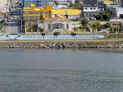
February 2, 2006
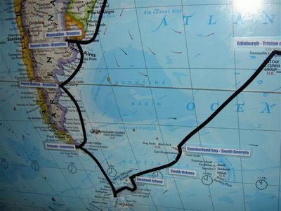
Welcome to Ushuaia, Argentina
Ushuaia is sometimes considered to be the southernmost city in the world, located on the southern coast of Tierra del Fuego in Argentina, in a setting surrounded by mountains and overlooking the Beagle Channel. The city has about 50,000 inhabitants. Some say that Puerto Williams is considered to be the southernmost city as it is further south, but has much less inhabitants, thus some consider it to be a town rather than a city. The more populated Punta Arenas is also sometimes considered to be the southernmost city, but it is north of Ushuaia. The southernmost continuously inhabited settlement is Puerto Toro on Isla Navarino, however it has less than 100 people. The city was originally named by early British colonists after the name that the native Yamana people had for the area. For most of the first half of the 20th century the city was centered around a prison for serious criminals. The Argentinean government set up this prison following the example of the British in Australia: being a remote island, escape from a prison on Tierra del Fuego would have been impossible. The prisoners thus became forced colonists and spent much of their time cutting wood in the lands around the prison and building the town. Also of interest is the Tierra del Fuego National Park to see the Bahia Lapataia on to the west on the border with Chile.
We will board the Argentinean pilot near Point Moat at 6:00 am and then continue to sail the 60 nautical miles passage, via Paso Mack inlay towards Ushuaia, leaving the Atlantic and entering the scenic inside passage. We expect to start our docking procedures and be docked at 10:00 am in the center of this small town, at Muelle de la Gobernacion (Government dock). After our departure at 6:00 pm we will once again sail in the Beagle Channel down to Cape Horn.
February 2, 2006
The Beagle Channel
Beagle Channel is a strait separating islands of the Tierra del Fuego archipelago, in extreme southern South America. It separates Isla Grande de Tierra del Fuego from several smaller islands to the south. Its eastern portion is part of the border between Chile and Argentina, but the western part is completely within Chile. Beagle Channel is about 150 miles long and is about three miles wide at its narrowest point. Although it is navigable by large ships, there are safer waters to the south, such as Drake Passage, and to the north, such as the Strait of Magellan. Several small islands near the eastern end were the subject of a long-running territorial dispute between Chile and Argentina; by the terms of a 1985 treaty they are now part of Chile. The main settlements on the channel are Puerto Williams, Chile and Ushuaia, Argentina. The Beagle Channel was named after the HMS Beagle, with which naturalist Charles Darwin explored the area in the 19th century. The ship was a Cherokee-class 10 gun brig of the Royal Navy, named after the Beagle breed of dog. She was launched on May 11, 1820 from the Woolwich Dockyard on the River Thames, at a cost of £7,803. She took part in celebrating the coronation of King George IV of the United Kingdom in which she was the first ship to sail under the new London Bridge. She was then adapted as a survey ship and took part in three expeditions. On the second survey voyage the young Darwin was on board, and his work would eventually make the Beagle one of the most famous ships in history. Continuing on a southerly course, we will pass the Argentina and Chile border on our starboard side, where the entrance to the Estrecho de Magellans (Magellan Strait) is located. This is named after the Portuguese explorer Ferdinand Magellan, who led the first expedition that sailed around the World (1519-1522). He also named the Pacific Ocean (the calm and peaceful ocean). On our port side, we will later pass the British Falkland Islands.
February 1, 2006
Explorations Speaker Dr. Bernard Stonehouse
Dr. Bernard Stonehouse served in the Royal Navy in World War II, then spent three years in Antarctica as meteorologist, pilot, dog-sledger, surveyor and biologist. After reading zoology and geology at University College, London, he lived for two summers and a winter with king penguins on South Georgia - a study toward MA and DPhil degrees of Oxford University. He has since spent many summers in both the Arctic and Antarctic, leading university-based research expeditions to study marine mammals and birds, including most recently the impacts of tourism on polar flora and fauna. He has held university appointments in New Zealand, Canada and Britain, and served in Antarctica with British, New Zealand, US, Argentine, German, French and Polish expeditions. He has received the Polar Medal for services in Antarctica, the Union Medal of the British Ornithologists' Union for long-term research on seabirds, the Voyce Trophy of the New Zealand Antarctic Society for conservation research in Antarctica, and was recently awarded an honorary Doctorate in Science by the University of Hull, for lifetime achievements in research and teaching. He holds honorary appointments in the Scott Polar Research Institute, University of Cambridge, and the Maritime Historical Studies Centre, University of Hull.